

Five hundred years ago, the streets we drive everyday in Malden were vast swampland dotted with rocky outcroppings and covered with dense forest. A wide, winding river cut through this hilly forestland and Indian tribes like the Massachusett could live safely under the cover of the forest and watch for enemies approaching up the river. Tidal salt water flowed into the river from the ocean and with it came abundant fish, shellfish and sea fowl, and the large furry animals which preyed on them, providing plenty of food and clothing for the Native Americans.

In the 1600s a few brave Pilgrim settlers from Boston found their way up the river and realized its value. The river provided a quick means of travel, alewife, blueback herring, oysters and clams could be found in the tidal stream and salt flats, the soil was ripe for planting and the trees that grew thick along its shores provided timber for building cabins.
According to The History of Malden, 1633-1785, by Deloraine Pendre Corey (1899), the Native Americans in the area were not much of a threat and some of them were helpful to the new settlers. Soon a small village popped up at a landing on the river called Sandy Banks. Nearby the villagers eventually started a burial ground, known today as Bell Rock Cemetery. Enterprising villagers began to sail timber up the river to sell in nearby Charles Towne and Boston. Eventually, the little village was named Mauldon, in honor of the settlers homeland in England.
As more people found their way up the river, industry followed. Between the 17-1800s the waters of the Malden River powered mills and factories, producing everything from energy, to lumber to rubber boots for soldiers, making fortunes for some and providing a very good living for others. Young Malden’s rural roots were being left behind in the name of commerce.

By the mid 1800s the curvy Malden River was the center of industry in the area. To improve accessibility, the river experienced its first alteration. The Malden Canal Project straightened, dredged and filled in portions of the river to allow barges easy access up river for delivery of lumber, coal and tar products. It was the biggest alteration of an inland waterway for industrial use in the country in that time, and in 1847, Otis Tufts turned the landing at Sandy Banks into a prominent wharf for unloading coal and lumber products onto what we now call Medford Street.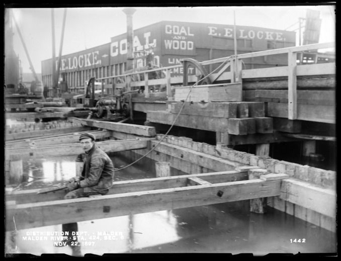
By the late 1800s, the original curvy shape of the river could not be recognized, as additional dredging, and filling had transformed it into a straight channel full of barges, ferries and the traces of pollution that would eventually become its demise.

For a city born on the banks of the River, today the Malden River is probably the city’s largest, best-kept secret.
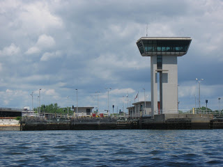
Beginning roughly at Spot Pond Brook in Melrose and flowing for approximately 2.3 miles, most of the river today has been channeled underneath the city of Malden, and can be heard rushing underground at a location in Coytemore Lea Park on Mountain Ave. It surfaces briefly at a few locations as brooks, until the Canal Street locks, and then continues above ground for almost two miles to the Mystic River.
Over the past 100 years, mostly due to abuse by the very factories and businesses which it helped to build, the Malden River has turned toxic. However, the historic waterway seems poised for a comeback.
Groups like Friends of Malden River (FOMR) and Mystic River Watershed Association (MyRWA) are probably the river’s biggest advocates. Among their many goals is to hold “legacy” polluters, like Honeywell Inc., accountable for the pollution they left behind and secure the polluters’ assistance in the extensive clean up necessary to make the river safe again. The groups also want to ensure the river remains accessible to the public and prevent future contamination as development along the river progresses.
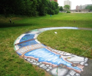
FOMR has started holding events like an annual River Festival and Outdoor Art Installations near the river in the hopes that the public will take more notice of the river and its potential. Citing the Massachusetts Public Waterfront Act, or Chapter 91, which seeks to preserve and protect the rights of the public to have access to the Commonwealth’s waterways, Karen Buck, spokesperson for FOMR stated, “It (the river) should be open to all of the residents.”
Today a new bike path runs along a portion of the river and in 2012, the city developed the Malden River Walk, allowing public access along the river that was previously unavailable. The Malden High and Tufts crew teams practice, organize trash pick up days and hold rowing competitions on the river, however, extreme care still needs to be taken while on the river because the levels of contaminants in the water remain dangerously high.
Long time Malden resident Hue Holley hopes in the near future the river becomes even more usable and that businesses open up their property for access. Referring to the work FOMR is doing for the river, he says, “We have some really good people on it.”
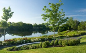
The opening of River’s Edge Park in Medford proved that the Malden River can become a beautiful place to gather, exercise and relax. Maybe in time, the city built by the river can re-build the river into a place for all to enjoy once again, and make it less of a secret.

Nice article. I had no idea of the extensive past on record and of the potential for the future. We use to fish for monster carp there and was an inside joke of them having two tails and three eyes. Has there been any successful litigation against the dirt bag companies that contaminated it.
I currently live in a house which belonged to the King’s grant of Increase Nowell. It was bordered on the south by Nowell’s creek;on the east by the North(Malden)River;on the west by the boundary with Medford;and to the north by the road called Salem Path(currently pleasant St). TheDwelling,like Malden and its river,has become a victim of a history which has largely been forgotten or just unknown to its residents. The house has provided shelter and comfort to its inhabitants since the early 1700’s while sending some of them off to fight in wars since the Revolution. The house has been part of the changes from wilderness,to farmland to modern urban life. It has welcomed-as has Malden , refugees from Nova
Scotia,England,Ireland,Poland,Vietnam,China and a multitude of other locales seeking that which each preceding group sought-and found-here in Malden. And like the city in which its located-its aging ,and creaky,an rickiddy–but is still able to adapt to the times in which it finds itself.
Great job Lisa in giving the backstory to the Malden River. It’s well researched and extremely informative.
Nice and important article! Thank you! Regarding Carl’s comment regarding past polluters, yes! The Friends of the Malden River (that includes you:) filed a Public Information Petition with Honeywell and their environmental consultants regarding their ownership (via purchase of Allied Chemical) on 378 Commercial Street (Little Creek). There is a past article on Neighborhood View regarding our success! We are in the midst of more legislation so join us at Cambridge Health Alliance (195 Canal Street) every second Monday at 6:30. The Friends hope to collaborate with local artists for outdoor art installations and are planning a river festival this fall, but those are future plans (Tri-Cap sponsored a festival at River’s Edge a couple of years back, but the continuum was stalled by the construction). We look forward to connecting the Malden River’s communities (Everett, Medford, and Malden) for the environment, the residents’ and the visitors’ healthy enjoyment of our natural resource. Stay Tuned! And thanks for Dick’s share of his piece of local history!
Reblogged this on Friends of the Malden River and commented:
The Malden River is receiving the attention it deserves! Thank you to the Friends of Malden River!
Awesome pictures if coytamorlea park!! Very informative too!!